Visit ALBUM - Art, history and entertainment picture archive to inquire about licensing high resolution images for professional or commercial use


by Album
$24.99
Color
Image Size
Product Details
Our baby onesies are made from 100% pre-shrunk cotton and are available in five different sizes. All baby onesies are machine washable.
Design Details
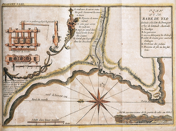
SOUTH AMERICA. PERU. 18TH CENTURY. MAP OF THE RADA DE YLO (currently ILO), main port located on the Peruvian coast. Plane of a sugar mill. RADA DE... more
Ships Within
1 - 2 business days

Drawing

Canvas Print

Framed Print

Art Print

Poster

Metal Print

Acrylic Print

Wood Print

Greeting Card

iPhone Case

Throw Pillow

Duvet Cover

Shower Curtain

Tote Bag

Round Beach Towel

Zip Pouch

Beach Towel

Weekender Tote Bag

Portable Battery Charger

Bath Towel

Apparel

Coffee Mug

Yoga Mat

Spiral Notebook

Fleece Blanket

Tapestry
SOUTH AMERICA. PERU. 18TH CENTURY. MAP OF THE RADA DE YLO (currently ILO), main port located on the Peruvian coast. Plane of a sugar mill. "RADA DE YLO", at 17.37 southern latitude, on the Pacific coast. French engraving of 1716. Library of Catalonia. Barcelona.
$24.99


There are no comments for PERU. 18TH CENTURY. MAP OF THE RADA DE YLO -currently ILO-, main port located on the Peruvian coast.. Click here to post the first comment.